Slovo autora

Servus, whoever you are. This blog offers you some tips for trips, links and my experiences with given tour. There could be also some interwievs or philosophical thoughs hidden here and there. But don't take them to seriously.
Don't hesitate to contact me in case you want to ask for info and also write comments if you like: tomasjavurek09@SPAMNOTgmail.com


Saturday, December 24, 2016

Rugghuebel

difficulty: -
month: November
beauty: 10/10


Winter arrived little bit sooner this season and offered us quite good snow conditions for ski-touring even to summits of Schwarzwald or Jura. This snow was however melted in few days, but we were already switched to the winter mode and our hunger after snow was big.
The Rugghuebel hut stays proudly above the Engelberg, which is hidden in mist and clouds covering Switzerland lownlands all Fall long. Since snow covered surrounding slopes from 2000 meters, the summer route from Engeleberg was still passable. Nevertheless, there was nobody, in the entire valley of the hut and we were only visitors in all-winter opened Winterraum.
There was enough snow to make a little tour. We intended to explore the glaciers bellow Wissigstock, but long shades on snow cover in shape of crevasses were ment, that crevasses are still not completely filled by snow. Thus, we decided to follow 55 (see map) track only to the pass on Rot Graetli. We descended from here to the bottom of the valley and used 533 c to get back to the hut. 


Days are short, and Winterraum of Rugghuebel hut is perfec place to spend a night with candels and bottle of wine. If you are there alone, I might get a feeling of only humans in the world, or at least in this valley. The approach of this hut might be more difficult in winter, but the more solitude you gain. Longer days and better snow conditions of early spring might be the best time to go there.


in the pass

Tuesday, October 25, 2016

Barrhorn

difficulty: -
altitude: 3610 m
month: October

I am reporting about this tour with little delay. The point is that being out there is real fun, but reporting ... you know. Although my words might not be interesting, check out the picture. To summarize very quickly: this is one of the easiest mountain with altitude over 3500 in the Alps. It is really worth to run it. For the ski-touring, I would personally rather choose the Brunegghorn next to it. Although Barrhorn is simple summer track, there could be some tricky sections in winter due to risk of avalanches.


Technical difficulties were not on the plan. I wanted to be alone. This area could be great choice for solitude, but only out of season of the Turtman hut (it serves as Winterraum). But this wasn't the case in early October, still few tourists (maybe appearing here from the same reason as me)  were there.

Actually, I intended to follow the north ridge to Brunegghorn over Schoellihorn. And I did few steps in that direction. But it was clear immediately that this plan would regard much more effort, because snow wasn't firm enough. Thus I turned into opposite direction and headed towards Barrhorn. 

the pass between Barrhorn and Schoellihorn

few steps in direction of Brunegghorn

summit of Barrhorn
 

Sunday, September 18, 2016

Sonnenspitze

difficulty: 5-
altitude: 2417
month: September

the best information can be found here:  sonnenspitze

Matterhorn of Ehrwald. It has still far from real Matterhorn, but its shape may certainly attract many climbers and hikers. There are two routes over south ridge, one is via-ferrata (good escape plan in case of bad weather) and the second is climbing route following the ridge very precisely. Whenever you don't know, where the route is exactly leading, go closer the ridge.

stolen from wikipedia
Unfortunately (or fortunately?), I forgot my camera hence the picture provided here is stolen from somewhere else. I regret it a little bit, since I could make really astonishing pictures of dramatic clouds and my beautiful wife hanging by crag in vertical sections. On the other hand, there is too much pictures, videos and all kind of stuff presenting how awesome people are (and I contributed already a lot as well), so why not to take it little bit more simpler and fluent with no cameras. It gives an opportunity to stay for a while and rather remember the moment or a view as strongly, as one is capable to do so. I really can realize that my remembers are stronger from this outing. And my wife is not talking about anything else, than Sonnenspitze. 


I like to the round trips not using the same way for descent. The trip has somehow larger value for me, if one can do full traverse of the mountain. The round has to make sense, although I can not tell any specific rules for that. My path on the map above could look a bit better, namely during descent, where we misleadingly used the route more on the east. There was one simple reason for that. The mountain hut over there serves incredibly tasty sweet dumplings with vanilla sauce. And once you eat such a good thing, you definitely don't want to climb up the hill back to the correct route. You simply rather descent the via ferrata marked as the most difficult (E), see the second exclamation mark in the map. This costed us 1 hour of time. On the other hand, it was quite an adventure.

At 7 pm, we arrived back to our friends to the camp. Well, in reality some of the friends were still hanging somewhere in the walls around Ehrwald, but this is different story.


Saturday, September 3, 2016

Ultraks 2016

I will update this soon.

Amazing run, with breathtaking views all the way long. I guess one of the most worthwhile run in the alps. Please don't read the shit I am going to write here, and just register yourself for next year here: ultraks

if you beat Killian's time, or if you are even close to that, you definitely doesn't belong to the earth, but to some other place in space-time.


Mt. Gele

difficulty: pd+
altitude: 3504
month: August

The difficulty is only roughly estimated. I found only one outing documented here.  At that outing, the required is set to 3b. Me personally, I would rise it a bit to 4a (ad-). But can well be, that we haven't found the most optimal route on the ridge. The route shall be however rated tougher due to the loose rock.


It is rather long tour from Mauvoisin and the such a tour directly from there is highly demanding. We intended anyway to reach also Ruinette, thus the decision was to use a camp at very convenient and strategical place, namely bellow the glacier du Brenay.

Mt. Gele, the west ridge on the right


The Monday started with clear sky and Martina, Dada and me enjoyed the tour to the pass Fenetre de Durand. Martina felt not in good shape a and returned back into BC. We started to climb first crags not roped. But soon, the difficulty of the climbed reached the level, that we decided to rope up.

On the left picture: Ruinette, on the right picutre: the ridge we intended to climb.

The ridge is pure. Pure in sense that there is nothing left from previous climbs. One needs to use purely his own belay. At the very low parts, we lost the most optimal route, and got to the wall on the right. This was however not a big issue, just moving up was little bit tougher. Real issues occurred at the middle of the ridge, where the rock becomes very loose. Holds and steps which one can not believe and reliability of own belay in this rock is very fishy.


Complete end of the ridge is again very nice. It looks like 100 meters of vertical crag, but in the end, it is quite easy. The tour back to BC was already easy, but still physically demanding. As one can see in the map, it crosses two passes and one still gain few altitude meters. We almost descended down onto Italian side, but the forests looked really weird -  I didn't remember any forests around the lake on the Swiss side. I took me a while to realize, that we are descending on wrong side of the mountain. Fortunately, we were in good physical shape, and returned the BC before the dinner - great Pasta prepared by Simone, who came from Mauvoisin just an hour before us. The fog covered the whole area in the evening, so we, as well as Simeone, were lucky to arrive on time.

Thursday, September 1, 2016

Aig. du Tour

difficulty: f
altitude: 3540
month: August
This one-day tour starts in Le Tour and leads to the summit of Aig. du Tour. Simply, it is nice glacier tour. My tour partner was Simone, with whom I have already climbed some crags.


The bottom part of the glacier can be walked without rope. Firstly, snow was firm, secondly crevasses were uncovered. But as we ascended higher and higher, snow was softer and softer, so we decided to rope up.


There is very fe technical steps last 100 metres bellow the summit. Firstly, one has to get over crevasse in steep snow field bellow the foot of the summit rock, and then the rock itself. Shall not be however an issue for most of the people.


The mountain gods: Chardonet, Verte, Blanc

The granite of Chomonix, white snow and blue sky are the wonderful combination, the pleasure for my eyes. I admit it would be better without the crowd of people. If I have that power, I would forbid them to come there. Fortunately, I have not that power and people can enjoy this mountain as well.

Beautiful unnamed peak, unfortunately, climbing there is quite short so it is not worth to take all the equipment. Maybe from the other side?

Descent back to Le Tour

Running. Another passion. Highly recommended. Only in mountains.


Monday, August 15, 2016

Mt. Ruan

difficulty: pd+
altitude: 2950
month: August

When I saw Mt. Ruan for the first time, I compared its north face to Aconcagua, see first picture in the outing: Dents du Midi. I knew at that point that I have to return there. I know also now that I have to return once again and maybe not only once.

Mt. Ruan is relatively small mountain, only 3044 meters high, but can astonish by its wildness. There are small glaciers with steps and falling ice. Its traverse from east to west is something, what could be already considered as mountaineering act. One could think of running this mountain with trail shoes. Well, ... almost. It would maybe work until Petit Ruan in case that all the snow is already melted. Except of the glaciated areas, there is not so much danger, but one needs to pass through some technical steps where belaying is needed (III-IV UIAA), please see second to last picture.


I decided for the ascent from the French side, with camp in the altitude of 2400 (see red 'C' on the map). It would certainly possible to do it in one day up and down. But why? This is pretty beautiful, calm place, so why to hurry? Ok, maybe it is just an excuse and I was so lazy. At some point, I sat down to the grass, started to read a book and I forgot about the summit. And it was quite cool, I have to say, much better than sweating, starving, suffering and all this kind of weird things I usually do. 


Astonishing waterfalls, blue-green lake and steep walls of Dents Blanches. I almost built my tent already there, but there was too many tourists to do so. After few more meters of altitude gain, really bad small hit my nose. I realized that there are excrements of capricorns all around. I was forced to go further, otherwise I would not have drinking water. Once one reach the pass, frontier with Switzerland, there is no grass any more. The excrements of capricons are however still there. 100 meters from the pass, on the slope on the right, I found a perfect place for camping, surrounded by rocks from three sides. And a view from there? Look at the picture below. 


Next day morning, I woke up little bit earlier and run that hill up. Since it was night, I lost my path very quickly, which wasn't very good. I can really only recommend to follow the signs and return back when you loose them. This however wasn't the problem. The problems occurred when I started to climb that last step before summit, shown on the picture below. There was one point in that crag (maybe it was the last technical step) at level of IV. I had no rope for abseiling and I wouldn't afford to climb this down during descent. On the other side, I was already satisfied from where I was. In the steep face, alone and happy. The summit of Mt. Ruan wasn't really important for me. And I really don't care even now if I ever climb this mountain up to the summit. But I'll come again for its beauty. Most probably with my wife.


Remark: there are also Mt. Buet and La Cheval Blanc in this area. Believe me, they are ugly. Sorry mother nature for these words. It is also partly human fault, since there are electric cables leading exactly between these two mountains.

Sunday, July 3, 2016

Aig. d'Orny

difficulty: 5b (5+)
altitude: 3150 m.
month: June

We had big plans in the area of Glacier d'Orny and Plateau du Trient. Classical rock climbing routes as well as Culoir Cropt, mix route at the level of D-.


The ascent from Champex to Cabane d'Orny took us approx. 5 hours. We were however slow, because of heavy rucksacks we carried and because of my exhausted legs after damn ultra-trail NSBNT.


Tuesday. We had a beautiful day in front of us. No stress. No rush.  No fear from the classic, route La Moquette. At 8am, we waited in queue where the route starts, like for tickets in cinema. After an hour of waiting, we could start our tour. 


And it was worth to wait. It is quite simple route, with lot of belay, amazing views and very exposed sections and the best quality of rock ever. It was like a dream.


After few hours of nice climbing, we reached one of my very best summits.

Descent started with rappelling of the last pitch. Then we walked over the stone field to the snow field in the east direction from the summit. Snow was very wet, ideal condition for sliding on boots. So I did, with a broad smile like young guy on a chute. But I fell down, and before I could use my ice-axe as a break, I hit first stones with my foots. They throw me into air and my body, out of control, did a somersault... I landed on the rock with my chest... A guide standing nearby run to me asking whether I am alive. I said something like: "Nevim ... I don't know ... I can not believe it, but it seems that I'm ok." After this acrobatic piece, the guide accompanied us the hut, and asked a doctor that was at the hut to check my chest.

I remember, that my uncle told me about similar experience that happened to him and few of my friends as well. Well, this is not the safest hobby one can do. And we all should admit that.  


Friday, July 1, 2016

Mt. Blanc

The highest summit of  the Alps is quite complex topic. All the outings that aim to reach its summit(s) are collected here.

West face - Alessandro-Berthod route

difficulty: D
month: July
altitude: 4700

CZ version of this outing can be found here:
lezec.cz 


This is one of my best. Seriously. This could be compared with our attempt to climb Shkhara. Also feeling were similar. Our aim was to repeat not very well-known Alessandro-Berthod route. And we were almost successful, except of two culoirs, which we climbed rather than following original route. In this way, we invented in my opinion very safe and technically quite demanding variant of original route. 


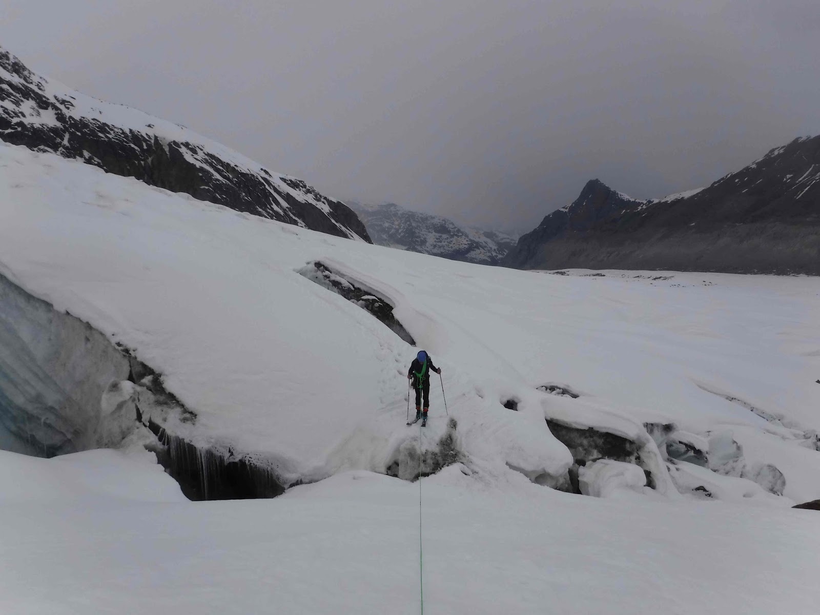
The access to the foot of the west face is little bit tricky, one has to cross quite crevassed glacier bellow the Gonella hut. This access can change each year, so I suggest everybody choose his own way.

We started our climb at 1:00, with headlights, in the terrain which we didn't know, which perhaps nobody knows. The fact that the first culoir (Carrot-cake), marked red in last topo-picture, worked quite smoothly is maybe more luck than our experiences.

The glaciated part of the route was very safe, not so much crevasses in our path. The key moment was the second culoir of the route, which was quite steep, and doesn't offer so much places for belay on the side rock. One has to use screws and snow-anchors.

Glacier and again other culoir (Paralen), added to the route by ourselves. This one I enjoyed a lot. The culoir is very narrow and one can nicely belay on its sides. There is even one nice ice step. Furthermore, I wouldn't expect any avalanche there. Stonefalls, of course as everywhere on this face. I ate all Mrkva's supplies of Paralen in this culoir, therefore the name.


Dehydratation, frustration, exhaustion, exposure. Just normal weekend with Mrkva. The last part of this route is following Tournette ridge. Very easy rock climbing, with two snow ridges close to summit. For me, it was infinite ridge with no future.


Victorious snooring of Mrkva in Vallot bivouac was making me surprisingly happy. It reminded me, that I am alive. I even didn't give a shit that I am sleeping in rubbish dump. If somebody pays a helicopter, I go and tide it. I need helicopter because I don't want to carry all the trash down. Let me know if somebody is in. 


Dome de Gouter

difficulty: pd-
month: June
altitude: 4304

Important note: Grand culoir is safe in June when it is covered by snow, stone are however frequently falling there later in season.


There are certain people that are able to run from valley to Mt. Blanc and back in 5 hours. It is not my case, unfortunately. I rather decided to go fully equipped and try to do it as fast as possible.


I started at parking place in Les Houches, where one can leave a car for 12 hours. I didn't expect to be so fast, but there is probably not any other option. After the pass below Mt. Lachat, one has to decide whether to go left over the steep slope or whether to follow the rail. I decided to go left, although there was still lot of snow and any visible steps. The wilder the better I thought at that point... I can not recommend that in mid June.


Finally, after short unintended climbing  intermezzo (I had to leave the path due to avalanche risk), the landscape opened and I could see my route leading over Aig. de Gouter to Dome de Gouter, see upper pic.

After another hour of silent walking in the frozen snow, I staid in front of mountain hut.  I found my place on bench at the terrace and tried to rest for a while. First customers of the hut woke me at 1 in the morning, and I followed their steps up to the stars. Somewhere at the ridge next to Grand Culoir, I stopped for a while, to see the snake of headlights bellow and above me. This certainly favourite summit of the Alps.


 But my steps were slower and slower, my breath faster and faster. When few old-laddies took over me, I accepted that I am not in the best shape. The summit of Dome du Gouter was clearly marked by my vomits. Fortunately, it is little bit out of the main highway. Reasonably, I left the Mt. Blanc to other mountaineers, and returned back to Les Houches by the same route. Entire trip took me less then 20 hours.


Thursday, May 12, 2016

Mt. Rosa - Punta Gnifety

difficulty: f
altitude: 4559 m
season: April

Yeah. Mt. Rosa. Intention was to reach all of its summits, finally, I am happy even with only one of them. We reached Punta Gniftety (Signalkuppe) in very bad conditions with great help of gps. We trusted it fully since it was only option due to very bad visibility. I have to admit that it works perfectly in 99% cases, which is much better than my own intuition. The missing 1% made the trip little bit more adventurous. 


Please, have a close look at the map. I tried to draw the route chosen by us as precise as possible. This route can well be the safest one. The green path was used during descent and it can be recommended as well.

Why I am spotting this: well, when we ascended by the blue path, the gorge (see the following picture) was fully covered by snow. Scary holes appeared in that snow layer just two days later when we descended, and several parts of the gorge were drown by river. Actually, I think we were quite lucky when ascending. However, green path is safe (avalanche risk in winter). 


Few meters below the Mt. Rosa hut on the glacier, there is a large crevassed area. We decided  to rope up. Yes, we are little chickens and of course, we don't confess such things before girls and in pubs. (I guess most of our pub-friends would give up reading this after first lines anyway.)


Weather was fine on Saturday, except from dense fog. The higher we were the worse the visibility was. Fortunately, I couldn't see how much is the glacier crevassed.  From certain point, we had to stop each 50 metres and ask gps locator where to go. Even though, there was one issue. We ended up in very steep slope covered by sheer ice. I intended to cross that in order to get back to correct direction. After few steps, I slipped off and fell until the Mrqa caught me into rope. This time, we wanted to be on safe side. But as you can see, bad conditions are never safe.


My fear even increased next morning, still on the summit in the 'Winterraum'. Although sky was blue, the wind was f..ing strong. Well, Mrqa finally convinced me, that we had to go outside and try to descend. Luckily, wind was calmer and calmer when descending.

Zumstein, Dufour, Nordend

summit above summits


Such nice freerides, like we had, one can not see even on Salomon freeski tv. And it was fast. Better then flying. Bad conditions for climbing, but perfect day for skiing.


Now, I could see the crevasses. We were lucky, what else can say.


We rested for a while under the glacier and already dreamed about our next outings. This is never-ending story. Wild white desert and two pig-headed chickens.